On July 16th 2024, Toronto was hit by a record-breaking rainstorm, with some areas getting up to 100 millimeters of rain in just four hours (CBC News). The city saw over half of its average amount of rainfall for July in just a couple of hours.
Following a particularly wet spring, Toronto’s infrastructure was not prepared to absorb this amount of water. The Don Valley Expressway and Union Station flooded and there was estimated insured damages over $940 million (over 5% of the city’s operating budget for 2024), according to the Insurance Bureau of Canada.
The Vale of Avoca is particularly vulnerable to flooding and subsequent erosion due to its depth and its function as a conduit for stormwater drains. The catchment area for the Vale of Avoca is an area of over 10 square kilometers, reaching as far north as Downsview.
The images below provide a comparison of the terrain with flooding caused by the storm, compared with the same location under normal conditions.
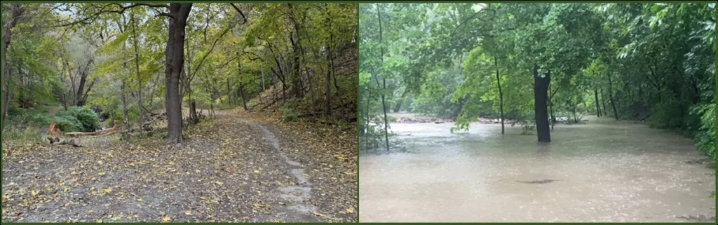
Area at south end of above-ground section of Yellow Creek. Left picture: November 2025; right picture: flooding of July 2024. (Photo credits: Tom Connell and Robin Miller)
Peak stream flows, as captured in this video footage, have contributed significantly to erosion in several sections of Yellow Creek, particularly at curves in the channel and where there are steep banks.
The continuing impact of elevated stormwater flows on Yellow Creek was a central focus of the Geomorphic Systems Master Plan (GSMP) issued by the City of Toronto in January 2025. The GSMP report highlighted that the present hydrology of Yellow Creek has changed dramatically from the early 1900s, by which time the quarried rock channel walls had been installed. Greatly elevated peak flows today are due to the increased frequency and severity of extreme weather events, and exacerbated by the paving over of much of the watershed, which was farmland a century ago. In the July 2024 storm event, approximately one million cubic meters of water fell on the Yellow Creek catchment area in three hours, suggesting peak storm flows well in excess of the creek’s 100-year flow event design parameter of 45 cubic meters per second cited in the GSMP. The full report and appendices can be found at the City’s Yellow Creek GSMP web page.
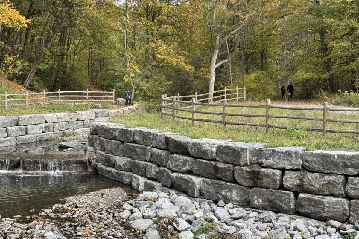
Ensuring the creek channel configuration is robust in light of future peak stream flows will be a central focus of the pending planning exercise for the Vale of Avoca. The channel reconstruction of one section of Yellow Creek completed in 2025 provides a sense of measures that will be needed to safeguard the resilience of the creek and the adjacent ravine slopes. That project involved robust stream bank reinforcement and drops to control water speed and flows (as shown in the photo at the top of this page). Wetland features to absorb surges in creek flows may also have a role to play.
As climate change intensifies and communities strive to adapt, the condition of ravines and streams throughout Toronto will serve as a report card on the City’s resilience. The payback for adequate capital investment to stabilize the creek channel and slopes of the Vale of Avoca will be an accessible green space that serves expanding local populations and wildlife for the next century and beyond.